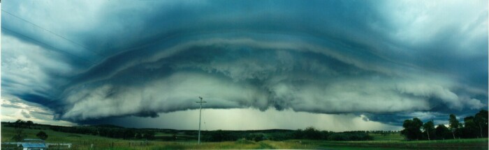
What do thunderstorms require? Lets think about this question for a bit. What do you notice on typical thunderstorm days? Are there features of days that tend to characterise thunderstorm days from other days? Well - yes! We tend to associate thunderstorm days with warm or hot, humid days. This guide will explain why - but also, it will look at how thunderstorms are also possible (and occur regularly in states such as Western Australia and Victoria), on those very cold days! Alright, so we have in our mind of a "typical" thunderstorm day. Well, here's the list of ingredients that are essential for thunderstorms: - Heat (some form
of heat is needed, even on those cold days!)
Now your heat will take a while to build up. Theres two ways you can get heat, either through advection (ie, winds blowing hot air into the area), and the other through the Sun. The latter is preferable but a combination of the two works well. Why do we need heat? Well, heat is the key to our mixture here that mixture is instability. Air will only rise on its own accord if it is lighter than the surrounding air for that to happen, it must be warmer as warm air is less dense that cold air. So if we have some warm/hot air at the ground itll (in theory) rise. And why do we want most of the heat to come from the sun? Convection starts off as small pockets of air that rise as they become warmer than the surrounding air. We want the ground to become hot too, that also helps retain the heat and helps get those thermals (pockets of air) rising. As opposed to a cloudy, but hot day - those thermals never really have the same potential. Typically, I'd prefer 30C and sunny over 35C and cloudy. Meanwhile, while our heat is starting to do some work lets assume it can ascend up into the atmosphere. What happens? Absolutely nothing! Woops, we forgot to add some moisture, given that thunderstorms are full of billions of little water droplets and hail/ice nuclei it makes sense that were going to need a lot of moisture. We want this moisture at the surface, not in the upper levels though. There are two ways we can get moisture, either through left over rain bands, or advected through by winds on the ocean (the latter is preferable, but some storms systems can "recycle" moisture from previous rain/storms over the same area over and over - especially in inland Australia, and can produce some beautiful storm systems from it!) Moisture is really what a thunderstorm consists of a column of water suspended up in the atmosphere. But the other reason why this is handy as it again is another vital ingredient in our instability mixture. Moist air contains latent (hidden) heat, basically I wont go into the reasons, but when water condenses, it releases heat! So if we have an updraft that is condensing water, then theres additional heat being released in the updraft. The significance of this is that the updraft parcel cools due to expansion as it ascends into the atmosphere. The addition of heat through to this process means it doesnt cool as quickly, so a parcel is more likely to be warmer than its surroundings as it ascends in the atmosphere, so its more likely to rise and helps with our instability! The thing to remember here, is we want the moisture in a layer at the surface (its no good if the surface DP is 20, and 100m above that the DP crashes to 5), the moist layer is too shallow. You want the lower 1km or so (approx 100mb) to be moist. More on moisture thickness in later parts. Ok so weve got our heat and moisture. Its 34 degrees and the DP is 25 but were staring at clear skies, why??? Lets add a trigger after all, something has to break through the cap in the lower atmosphere, right? A cap acts as a lid on convection, its sometimes incorrectly referred to as an inversion (where air warms with height), but a cap can occur without an inversion. In fact, if you look at how a parcel of air will rise in its dry rate, and its wet rate you can soon see that a cap is a naturally occurring phenomenon in most cases. So this small stable layer has to be broken, to allow our updraft parcels to continue to ascend into the atmosphere. A cap may be broken by the shear force of an updraft parcel without any other influence, but often there is some sort of low pressure area around that. So ways to break the cap may include ranges (forcing air upwards, and elevated heating) and fronts/troughs/low pressure systems where air is converging/confluencing in an area and moving upwards into the lower atmosphere. So essentially all up, were just trying to force the air parcel through a small stable layer. The other ingredient is highly relative (so is much of the above), you need cooler air aloft. You dont necessarily need a great big upper level trough, but just air that is cold enough to allow your surface obs to create an unstable air parcel. If the air in the upper atmosphere is too warm, then you might find that no matter how much moisture/heat/triggers you have that you wont get anything. Upper level ridges can be killers they can suppress strong updrafts in some cases! If we put all of these ingredients together we should have instability and a trigger and in *theory* have a storm developing. I stress in theory, there is obviously much more to it. This has touched on the absolute basics and has used a lot of generalisations (and as they say, all generalisations are false!)
|