Introduction to Forecasting Severe Thunderstorms Ok, we've baked our cake (made a thunderstorm) using some instability and a trigger. Not only that, we know what some of the ingredients actually mean. How about some icing on that cake? Fancy some: - 2cm+ hail?
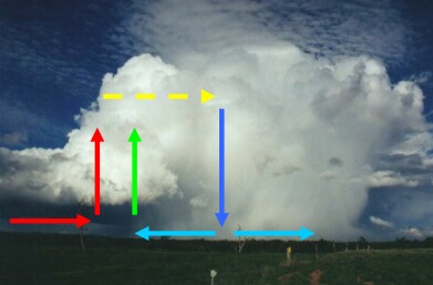
Well, we need to add a little bit extra to the environment, depending on what we want. I'm going to generalise here - I'm going to say you need good wind shear for severe thunderstorms. This however is not always true! (Remember, all generalisations are false! :) But it is true for the majority of cases - for more information on severe storms in no shear, see severe thunderstorms - breaking all the rules! In order to simplify, I'm going to take the majority of cases. Lets think about how a storm might move, and lets also think about the structure of a thunderstorm! A thunderstorm contains vast quantities of water - if we put all of this water up in the atmosphere, it has to go somewhere! Some of it falls back as rain or hail, but some of it remains as cloud. Remember - what goes up, must come down!
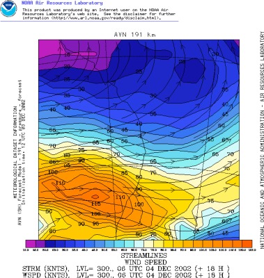
For instance, lets start at the 300mb (approximately 30,000ft) level. Think of this windshear as an "exhaust" - it has to blow all of the waste anvil cirrus away. What typical speeds would be adequete for this? Here's a rough guide based on my observations in Australia...opinions will differ no doubt, but these are my thoughts. 300mb Winds
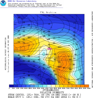
Ok, so we have organised our thunderstorm's "exhaust" - we can use differing charts to see this. For instance, FNL is a great way of looking at winds:
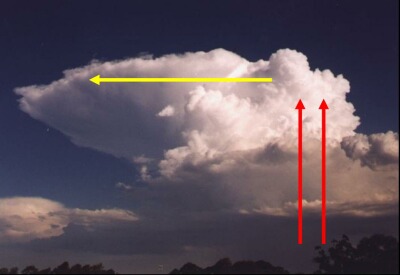
This is a plot of the 300mb winds from the December 4 supercell through south Brisbane in 2002. Brisbane (the asterix) has 50 knot WNW winds at 300mb, which fits in nicely with our table above. A much stronger jetstream was lying to the south (110-120 knots!) but unfortunately there was no instability there. So we've completed looking at 300mb (well, the basics anyway). Lets do this differently, and think about the surface. Think about an updraft - all of that air moving upwards! It has to come from somewhere, so where? Well, the surrounding surface air forms the basis for our updraft, but what happens when that air moves into the updraft? It has to draw in more air from its surroundings. That's a lot of work for our poor little updraft that has only just begun its life in our world! It's not going to have a very long lifespan if it has to keep producing its own inflow! What's a way to speed this process up? We could have a low level jet (say at the surface, or even 925mb, which is about 1km above the surface). That would certainly help things a lot! A well organised storm will have very defined inflow and outflow regions, for instance here's a photo of a supercell SW of Brisbane on November 4, 2000:
This photo is taken to the NW of the storm. You can see a small inflow band coming in from the NE, and then the outflow coming from around the back at the SW. This was a high precipitation supercell, but weakened significantly before moving over the western suburbs of Ipswich, however it gave extensive hail damage south of Ipswich near Warrill View. The inflow into this storm was well organised with a 15-20 knot NE'ly into the storm which helped it survive. Lets look at another situation when the inflow is too weak:
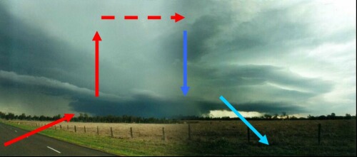
Here you can see the inflow area into the updraft on the left. However the downdraft is still above to push against the inflow area and the updraft is sucking up some of the cooler outflow. This is a photo of a dying storm in the Capricornia region. This should hopefully give you an idea on the advantages of having reasonable inflow, but what speeds are we looking at? Well, as a guide... Surface Winds
Remember, these are the pre-existing winds, not the winds around storms! Winds around storms are often stronger, for instance inflow on the November 4, 2000 supercell above was in excess of 35 knots further south of my location! However had there not been a pre-existing 15-20 knot NE'ly, then the overall inflow may have only been around 20 knots and the storm may not have become as large or severe. What about low to mid level shear? There are certain (somewhat arbitrary) levels that are normally used, we've looked at two of them (surface, or 1000mb, and 300mb) already. Other levels that are normally used are 850mb, 700mb and 500mb. We want moderately strong winds at 850mb, and then a good flow at 700 and 500mb is preferable. These winds (especially 700mb and 500mb) are often referred to as the steering winds, the stronger these winds are then the faster storms will move. Storms that move relatively quickly normally gather good inflow - it's important that a storm moves as if it stays still, it might exhaust all of the energy around it (ie it could cool the surface area around it, therefore stabilising the immediate atmosphere). Or we might encounter the problem we've discussed - the updraft and downdrafts may not be well separated and the updraft may begin to draw in some of the cooler air from the downdraft which certainly is not what we want for strong or severe thunderstorms! On the other hand, while having something like 30 knots @ 850mb, 50 knots @ 700mb and 80 knots @ 500mb seems fantastic! You're going to have storms moving at around 70-90km/h! Great if you're in the immediate path of a storm (well, sort of - and you can stay ahead on the one road), not so great otherwise. And from experience, the "otherwise" constitutes 90% of chases. A fast moving storm is not good to chase because it's too difficult, on the other hand if it moves too slow it might weaken or worse, collapse! So what type of winds do we want at these levels? Trying to decide this can be quite difficult because it really depends on the speed of winds at the other levels, eg if the 700mb and 500mb levels are quite strong, then if the 850 winds are weak it won't matter as much as if all of them were weak. But anyway, here's a rough guide of what to look for in a "warm cored" situation (eg spring/summer setup). If you look at winds a bit more you'll begin to notice what I mean by if one or two level is lacking, it's not as bad as if they're all lacking. In a way, shear in other levels can "make up" for poor shear elsewhere. Remember though - we're only looking at single levels here! Essentially we're choosing 5 levels in the atmosphere to represent the entire shear profile! This is where something like a Skew-T diagram comes in handy, as that shows you immediately 20-30 levels which gives you a much better representation of what shear is really like! Anyway, here's an approximate guide (again, focusing on Australian situations). I've also thrown in 1000mb and 300mb as a reference point. Wind Strength Guide
This is a table that gives an idea of what type of winds you would be wanting for strong to severe thunderstorms - at least, this is what I look for at a general rule. Ok, that's the first part of shear (yes, first part...there's more to shear! There's also divergence, convergence, diffluence and convergence to look at and directional shear too! But this is enough for the moment and to help understand the basics). There's another important aspect of severe thunderstorms - that is upper level moisture. It might seem odd, but in the mid-high levels (eg, above 700mb), you don't want much moisture! In fact, the drier the better! There are several reasons, but one of them is that dry air means that waste anvil cirrus, and the edges of storms will evaporate. That provides cooling of the air around it and also means that cloud is unlikely to develop around the storms. Cloud will block out the sun and therefore block out heat! So it's good to have low levels of moisture if possible in the upper levels. Anything below 70% is reasonable, below 50% not bad and below 30% even better - especially at the 500 and 300mb levels (probably the more critical levels to have dry air at). Dry air in the mid levels also increases the chances of microburst activity which is often severe. Assessing moisture in the upper levels is extremely easy! A 500 or 300mb moisture chart from FNL will do the trick nicely.
This shows 50% RH over Brisbane at 500mb for our December 4, 2002 supercell, not bad! A word of warning when looking at forecast charts of RH. You're looking for broad sweeping bands of large moisture, the model is also going to pick up moisture from the storms themselves in the upper levels, so it may not be unusual to see "splotches" of large RH in small areas, don't automatically assume that you're going to get a big cloud area there. To be honest, I don't look at RH maps at the mid-upper levels very often, I prefer to look at the satellite image as I think that's going to give you a much better idea of whether there is going to be cloud or not, and a Skew-T. Probably the last thing (and very important)
for the best severe storms, is a cap. A cap is a small stable layer
in the low levels that inhibits convection. You might be surprised
that we want something to inhibit convection! Well, the best severe
storms occur when the heat of the day is at its maximum. If storms
were to start developing at 11am, then that uses some of our heat energy
and converts it into storms. Now, if they started developing at say
3-4pm, then that heat energy has been building up all day and it is ready
to all be used up by the storms then and there! The best days that
I have chased have actually had a strong cap that broke late - although
it does add some suspense to it, as sometimes you begin to wonder if anything
will develop! (If the cap is too strong, then that's no good either
as then you get no storms!) I'm not going to say much more at this
stage on capping, except that I often look at 850mb temperatures to get
an idea on the cap. But the problem is that it is difficult to give
an idea on what type of 850mb temperature you need as this is strongly
relative to the surface temperature and the time of year. The best
way to learn is to look at a Skew-T, but for now, if I were looking at
a "typical summer situation" then I'd be thinking the following:
Remember, cap is very relative to the surface temperatures! When I explain Skew-Ts you'll see what I mean. Until then, lets use our knowledge to "forecast" a real storm day... |