Severe Thunderstorms in Low
Instability
This was an interesting little day. It produced a small tornado through the southern edge of Ipswich, with other possible tornadoes reported in Brisbane (only weak also thankfully!) The tornado I encountered was rain-wrapped and it actually passed within metres of the car! (My car nearly got pushed off the road)...once again, check the chase report to get an idea on what happened on this day. This was an interesting day...don't see too many of them up here in Brisbane. You'll see what I mean...first lets look at some instability.
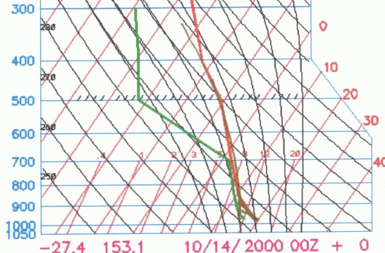
Interesting plot here...do I have the right day? Yeah I do! Did I plot the right temp/DP on it...well, it got a lot warmer than 20C...but the squall line was pretty much all over by 10am! I've plotted an archived FNL sounding here...if you see the chase report there's a sounding at 10am which was plotted with even less potential than this! So I'm perhaps even over-estimating the instability! But it did dry out a tad by the time the sounding went up. Lets check the CAPE...
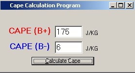
175!!! And there was a tornado!!!!! (Possibly more than one) - what on Earth is going here!!! These tornadoes are what (Victorians) call "cold air tornadoes." It can be a bit of a misnomer because tornadoes can form in similar situations in "warm air" - but essentially "cold air tornadoes" develop in high shear profiles with limited instability. So if shear was that good lets get cracking! Although I want to point something else out - it's not just the shear, it's the dynamics. The air around the area was rising fast and that was helping storms - and also keep in mind that this situation actually developed the day before and became a squall line. Sometimes you can get high shear days with low instability that just don't work because the updrafts just aren't strong enough to stand up to the shear. So it can take a bit of discression to try and work out these "boundaries." I'm going to use an 18z surface map to get an idea what the surface was like prior to the event, and then use 00z 850mb and above maps because they're more relevant to the time when the squall line and tornado went through SE Queensland.
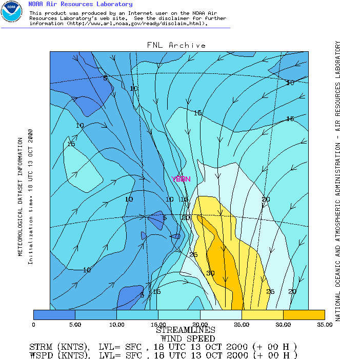
You can see the trough/front just to the west of Brisbane giving a probable dryline along the periphery...the day before we had some rain, so plenty of moisture ahead of the front. Also, some fairly strong northerly winds, 15-20 knots over Brisbane...decreasing closer to the front, but prior to the front, northerlies were quite strong! 20-25 knots or so which were very nice! A quick look at surface moisture will show that the main dry air is sitting just behind the trough (so along the front). Note how SE QLD/NE NSW stays relatively moist, even though how in previous sections it was taught that an ill-defined boundary can cause dry-air mixing? We were lucky that we had rain the day before...it kept things moist and delayed the dry air somewhat! Onto 850mb...
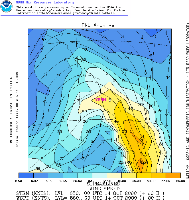
Our directional and speed shear wastes no time either when you check out 850mb! 40-45 knots over Brisbane...very impressive!!! In fact, if you were to look at our approximate supercell threshold, it's pretty much just been satisfied already going from the surface to 850mb...yet we're going to expect even stronger shear as we go higher in the atmosphere... 
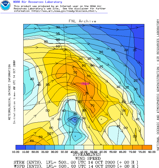
The 500mb shear was nothing short of awesome either...solid 75 knot WNW'ly over Brisbane and SE Queensland! Certainly looking good shear wise...lets check that cold pool which is responsible for the shear!
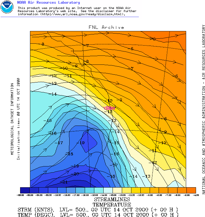
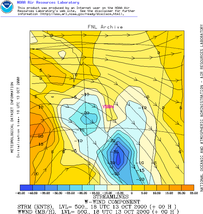
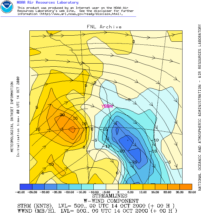
That's a great cold pool down in S NSW, and there's a small extension pushing northwards which is providing the shear. Remember how the strength of upper cold pools/troughs can be seen by looking at how much colder the air is to the relative surrounding regions of the same latitude? Have a look to the east of the -19 cold pool...getting down to -9/-10 there! So we know it's pretty considerable (although the -9 to -10 is quite warm for that region in October). But just seeing how much the cold air protrudes into warmer air should give you some idea about its strength. We also know that strong temperature gradients cause strong pressure gradients in the upper levels and therefore causes strong shear...and this certainly shows it well! Lets check the vertical motion at 500mb to! I'll do 18z and 00z, because during those terms the favourable vertical motion moved over SE QLD...
You can see here how fast this system was moving with favourable VVs moving quickly off the coast (although still hugging the coast at 00z)...some nice upmotion though, -15 to -20! So the vertical motion is enhancing the updrafts, possibly contributing to additional "effective CAPE." And finally 300mb shear...
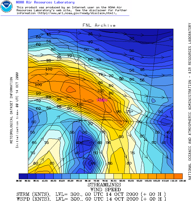
300mb didn't disappoint either...110 knots over Brisbane...this is some fantastic speed shear and directional shear is pretty good too! This is primarily the reason that such an event (ie tornado) developed on this day, even though instability was extremely poor (CAPE of 175, LIs barely negative!) Certainly it shows that just how shear isn't everything, neither is instability - and it demonstrates how one can offset the other. And it's just yet another situation where thunderstorms decide to break the rules! |